Home
West Dulwich Street Improvements
West Dulwich Street Improvements
Background
Lambeth’s 2019 Transport Strategy sets out priorities for the local transport network:
- SUSTAINABLE GROWTH: For Lambeth to continue to thrive we need new homes, jobs and investment in our borough. We need to ensure this growth is not car-led.
- INCLUSIVE AND ACCESSIBLE: Many of our roads have been designed without considering the needs of people who aren’t drivers. We need to make it easier for people walking, wheeling and cycling.
- EFFICIENT AND CONNECTED: We know we have limited space and as we plan for the future, we need quick and reliable routes to travel around Lambeth. We need to take advantage of new technology.
- ACTIVE AND SAFE: Transport is both a cause and a potential solution to public health issues. By discouraging traffic we can reduce road danger, the risk of poor health due to pollution and encourage daily exercise.
- CLEAN AIR AND CARBON NEUTRAL: We need to move swiftly towards carbon neutrality by 2030 to respond to the climate emergency we face.
Between 25 January and 25 March 2022, people in West Dulwich were asked which improvements they would like to see on their streets. As well as speaking to people, traffic data was gathered across the area. Community feedback and data collected showed that some streets experience high volumes of traffic travelling through the neighbourhood, often to/from the A205 south circular.
As well as reducing traffic, community members told us that they would like the plants and greenery in their area to be better maintained. We also heard that people would be encouraged to walk/wheel and cycle more by providing more cycle parking, more places to stop and rest and for the pavements to be repaired where they have been damaged by tree roots. Based on these findings, a variety of street improvements are proposed.
Street Improvements
West Dulwich Street Improvements are designed to make the neighbourhood safer, healthier and more climate resilient. To achieve this, a range of street improvements are proposed, which aim to:
- improve conditions for walking/wheeling and cycling
- reduce road danger, congestion and emissions
- improve the street environment and create more community spaces.
Some street improvements can be introduced easily and placed on top of the existing street layout, and others take longer to design and install, and require reconstruction of the street. Some improvements can be introduced on a trial basis and others are more permanent. The proposed improvements have been divided into 3 phases:
Phase 1 improvements are designed to support people to walk/wheel, scoot, cycle and enjoy the local area, by providing:
- cycle parking
- resurfacing uneven sections of the pavement
- maintaining plants and greenery
- parklets that provide places to rest and play
Phase 2 is a trial of traffic management improvements to reduce road danger, congestion, and emissions from motor-vehicles, using:
- camera-operated traffic filters
- banned turns
- one-way sections
The target for launching phases 1 and 2 is Summer 2023. A third phase is planned, consisting of further street improvements, such as pedestrian crossing facilitates, junction upgrades and improvements to public realm. Proposals for phase 3 are being developed and will be published at a later date.
Phase 1 and 2 Proposals
After collecting and analysing traffic data, engineers explored options for:
- Prohibiting external motor traffic cutting through the neighbourhood, whilst ensuring that all addresses within the neighbourhood remain accessible by car
- Improving conditions for walking/wheeling and cycling around the neighbourhood, and improving the street environment
To achieve these goals, the following ideas are proposed as a trial:
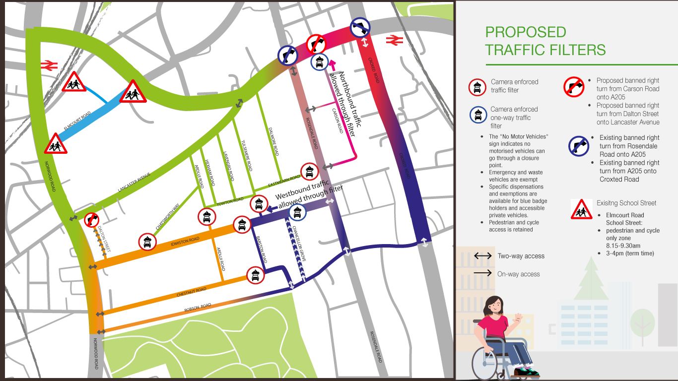
- Traffic filters – Automatic Number Plate Recognition (ANPR) cameras allow access to cycles, emergency and waste vehicles, and vehicles with registered dispensation (e.g. blue badge holders), and prohibit motor vehicles that do not have registered dispensation (by issuing a fixed penalty notice). Where traffic filters are used, all addresses remain accessible by car.
- One way traffic filters – allow access to cycles, emergency and waste vehicles, and vehicles with registered dispensation. They also allow access to motor vehicles without registered dispensation in one direction and prohibit motor vehicles without registered dispensation in the other direction.
- Banned turns – prohibited motor vehicles from turning in a certain direction
- One-way streets with cycle contraflow – all vehicles can travel in one direction, with cycling permitted in the opposite direction
- Coloured surfacing is used to suggest a pedestrian-focused area and to encourage vehicles (including cycles) to move with caution and give priority to pedestrians within these areas. It can also be used to show where more permanent changes could be made (as part of phase 3), such as widened footways.
The following ideas are proposed on a permanent basis:
- A Parklet is community space that sits on the kerbside. They are great for bringing people together and providing local green space. Lambeth have partnered with Living Streets to find out what people would like in their parklets.
- Pavement resurfacing uses a flexible material called ‘flexi-pave’ to repair sections of pavement damaged by tree roots. It allows tree roots to grow and thrive without disrupting the pavement surface
- Dropped kerbs are sections of kerb that are gently sloped so that they are flush with the road, making it easier for people using pushchairs, wheelchairs or other wheeled mobility aids to cross
- Cycle Parking – ‘Sheffield stands’ are free, fixed cycle parking.
It was clear from initial consultation that residents were worried about the risk of traffic being displaced onto streets which are currently quiet, as a result of installing traffic filters. The proposed design uses a range of traffic management measures to both reduce traffic where volumes are already high, and to prevent traffic displacing onto neighbouring streets.
Phase 1 - Proposed Street Improvements:

Phase 2 - Proposed Traffic Management Trial:
Follow the links below for more information on proposed changes:
- Elmcourt Road
- Dalton Street
- Chatsworth Way
- Towton Road/Ardlui Road
- Lancaster Avenue
- Dalmore Road/Eastmearn Road
- Tulsemere Road
- Idmiston Road/Chestnut Road
- Idmiston Road/Chancellor Road
- Rosendale Road
- Carson Road
- Robson Road
Existing traffic and congestion issues on Lancaster Avenue and Rosendale Road
Lancaster Avenue: We are aware of high volumes of motor traffic using Lancaster Avenue as a cut through between the A205 South Circular and Norwood Road, particularly at peak times. TfL will not permit a traffic filter due to the low railway bridge between Lancaster Avenue and the Tulse Hill gyratory, which tall vehicles are not able to pass underneath. Lancaster Avenue serves as the primary alternative for over-height vehicles who cannot fit under the bridge. The Lambeth team have requested a traffic filter that can exempt over-height vehicles or vehicles of 3.5 tonnes or over. TfL have informed us that this is not possible because:
- Signs do not exist that would allow this type of exemption
- If signs were created, they could cause confusion, as motorists are used to seeing signs that prohibit larger vehicles, not exempt them. There is a risk that over-height vehicles would interpret the sign as prohibitive and would, therefore, avoid Lancaster Avenue, increasing the risk of them striking the bridge.
- New road signs must be agreed by the Department for Transport, which could take up to 12 months.
We will continue to explore potential improvements to address traffic and improve conditions for walking/wheeling and cycling on Lancaster Avenue.
Rosendale Road: We are aware of congestion on Rosendale Road at peak time caused by northbound traffic queuing at the junction with the A205. Lambeth are working with TfL (who are redesigning this junction) to explore options to improve signal timings and reduce northbound traffic.
The traffic management trial
If approved, the trial would be installed under an Experimental Traffic Order (ETO), which would. last for 18 months.
Installing these measures on a trial basis allows for the impact of the project to be measured against the objectives, and for improvements to be made. Impact will be assessed based on:
- Traffic counts that will show flows, speeds, and number of vehicles on all streets within the neighbourhood and the surrounding roads
- Impact to local bus route 322
- Numbers of people cycling
- Numbers of people walking/wheeling (using Telraam citizen science counters - more information below)
The project would be monitored throughout the trial period, with traffic counts conducted at the following times:
- Initial adjustment - within 3 months of installation
- Settling down – within 6 months of installation
- Regular use – within 18 months of installation
Next steps
- Your feedback is important and will help shape and improve designs. We welcome your feedback on proposals between 11 April and 7 May. We understand that there may be postal delays due to the May bank holidays, therefore we will accept contributions on the commonplace website or by post up to a week after the consultation period closes.
- Once consultation closes, feedback will be analysed and will inform changes to the proposals
- Your feedback and traffic data collected will be captured and shared in a report along with updated proposals
- Once proposals have been agreed, the Cabinet Member for Sustainable Lambeth and Clean Air will be asked to make decisions on:
- whether to commence an 18-month trial for the Street Improvements (under experimental traffic orders)
- whether to commence statutory consultation on permanent traffic orders for the CPZ and Healthy route
- Once decisions have been made, they will be publicised
For more information, please see the Frequently Asked Questions
Elmcourt Road
Free cycle parking (Sheffield stands) is proposed outside Elmgreen school to serve parents, teachers and students
To comment on proposals, click here and drop a pin on the map.


Dalton Street
- A one-way system is proposed on Dalton Street, due to it being narrow (5m between parked cars), which is well below the minimum distance required for two-way traffic. The proposal is intended to improve traffic flow by removing conflict between vehicles travelling in opposite directions in insufficient space.
- A contraflow system for cycles is proposed. There is space to allow cycles to travel in the opposite direction to the one-way system. Islands are provided at each end of Dalton Street to protect cycles using the contraflow by separating them from north bound traffic.
- A banned right turn prevents northbound vehicles using Dalton Street as a cut-through to access Lancaster Avenue.
To comment on proposals, click here and drop a pin on the map.

Chatsworth Way
- A camera-enforced traffic filter is proposed at the south end of Chatsworth Way to prevent motor traffic cutting through. All addresses remain accessible by car. Space is provided next to the filter for larger vehicles (e.g., delivery vans) to turn around safely.
- A physical traffic filter is proposed across the small arm of the junction to create space for vehicles to turn and to prevent traffic cutting through.
- New dropped kerbs are proposed to make crossing easier for people using pushchairs, wheelchairs or other wheeled mobility aids
- Coloured surfacing is proposed to suggest that this is pedestrian-focused area and encourage vehicles (including cycles) to move with caution and give priority to pedestrians.
To comment on proposals, click here and drop a pin on the map.


Towton Road/Ardlui Road
- A camera enforced traffic filter is proposed on Ardlui Road immediately south of the junction with Towton Road to prevent motor traffic cutting through. All addresses remain accessible by car
- Coloured surfacing is proposed to show where the footway could be built out to provide more space for pedestrians
- Maintenance is proposed to address damaged or overgrown plants in planters along Towton Road
To comment on proposals, click here and drop a pin on the map.


Lancaster Avenue
- The Lambeth team are exploring options to reduce traffic speeds and improve safety for walking/wheeling and cycling on Lancaster Avenue. These proposals will be shared as part of Phase 3
- A Parklet is proposed on Lancaster Avenue near Rosemead School. The design of the parklet will be determined through community engagement led by Living Streets.
We are aware of high volumes of motor traffic using Lancaster Avenue as a cut through between the A205 South Circular and Norwood Road, particularly at peak times. TfL will not permit a traffic filter due to the low railway bridge between Lancaster Avenue and the Tulse Hill gyratory, which tall vehicles are not able to pass underneath. Lancaster Avenue serves as the primary alternative for over-height vehicles who cannot fit under the bridge. The Lambeth team have requested a traffic filter that can exempt over-height vehicles or vehicles of 3.5 tonnes or over. TfL have informed us that this is not possible because:
- Signs do not exist that would allow this type of exemption
- If signs were created, they could cause confusion, as motorists are used to seeing signs that prohibit larger vehicles, not exempt them. There is a risk that over-height vehicles would interpret the sign as prohibitive and would, therefore, avoid Lancaster Avenue, increasing the risk of them striking the bridge.
- New road signs must be agreed by the Department for Transport, which could take 12 months or longer.
We will continue to explore potential improvements to address traffic and improve conditions for walking/wheeling and cycling on Lancaster Avenue.
To comment on proposals, click here and drop a pin on the map.


Dalmore Road/Eastmearn Road
- Resurfacing sections of pavement that have been damaged by tree roots is proposed
- A pedestrian and cycle only zone (using two camera-enforced traffic filters) is proposed at the east end of Eastmearn Road, to create an area focused on pedestrians and cycles that also provides a parklet and cycleparking. Emergency and waste vehicles and vehicles with registered dispensation can still pass trough this zone. All addresses remain accessible by car.
To comment on proposals, click here and drop a pin on the map.


Tulsemere Road
A camera-enforced traffic filter is proposed on Tulsemere Road, immediately south of the junction with Towton Road to prevent motor traffic cutting through. All addresses remain accessible by car.
To comment on proposals, click here and drop a pin on the map.


Idmiston Road/Chestnut Road
- A camera-enforced traffic filter is proposed on Idmiston Road, immediately west of Barston Road to prevent motor traffic cutting through. All addresses remain accessible by car
- A camera-enforced traffic filter is proposed on Chestnut Road, immediately west of Barston Road to prevent motor traffic cutting trhough. All addresses remain accessible by car.
- Resurfacing sections of pavement that have been damaged by tree routes is proposed
To comment on proposals, click here and drop a pin on the map.


Idmiston Road/Chancellor Grove
- A westbound one-way traffic filter (enforced by cameras) is proposed on Idmiston road, immediately east of Chancellor Grove. This will allow access to westbound motor traffic and prohibit eastbound motor traffic, except emergency and waste vehicles and vehicles with registered dispensation.
- A one-way system with cycle contraflow is proposed on Chancellor Grove.
These two interventions are designed to prevent vehicles cutting through, while allowing access to all addresses and creating a loop, to mitigate the risk of larger vehicles (e.g., delivery vans) having to turn around or reverse unreasonable distances. This also enables parking and loading bays to be retained at the east end of Idmiston Road.
To comment on proposals, click here and drop a pin on the map.


Rosendale Road
- A Parklet is proposed on the pavement between trees (opposite Elmworth Grove). Design of the parklet will be determined through community engagement led by Living Streets.
- Maintenance is proposed to address damaged or overgrown plants in planters along Rosendale Road
- Proposals for the Brockwell Park to Gipsy Hill Healthy Route (phase 3) can be found here
We are aware of congestion on Rosendale Road at peak time caused by northbound traffic queuing at the junction with the A205. Lambeth are working with TfL (who are redesigning this junction) to explore options to improve signal timings and reduce northbound traffic.
To comment on proposals, click here and drop a pin on the map.


Carson Road
- A one-way traffic filter (enforced by cameras) is proposed at the north end of Carson Road. This will allow northbound motor traffic and prohibit southbound motor traffic, except emergency and waste vehicles and vehicles with registered dispensation.
- A banned right turn from Carson Road onto the A205 south circular.
These two measures will prevent motor traffic cutting through Carson Road to avoid the traffic lights and the banned left turn at the north end of Rosendale Road.
To comment on proposals, click here and drop a pin on the map.


Robson Road:
We are proposing to extend the existing double yellow lines on Robson Road to create wider passing places to improve flow of traffic, including the 322 bus.
To comment on proposals, click here and drop a pin on the map.


West Dulwich Street Improvements - Frequently Asked Questions (FAQs)
What are the West Dulwich Street Improvements?
West Dulwich Street Improvements are a range of measures designed to make the neighbourhood safer, healthier and more climate resilient.
How will they improve the streets?
1. Reducing Traffic has many benefits, including:
- Cleaner air and less noise
- Fewer emissions contributing to climate change
- Safer streets, which support people to walk/wheel and cycle when possible
- Less congestion, making journey times quicker for buses and essential motorised journeys
The objectives are:
- Preventing motor vehicles cutting through the neighbourhood
- Reducing overall traffic across the neighbourhood and on the boundary roads.
2. Improving walking/wheeling and cycling conditions benefit the community by supporting people to make active journeys that improve health and wellbeing, when possible. As well as reducing traffic, the following are proposed to improve walking/wheeling and cycling conditions:
- Repairing sections of pavement that have been damaged by tree roots
- New dropped kerbs to make crossing easier for people using pushchairs, wheelchairs, or other wheeled mobility aids
- Providing areas to stop and rest
- More cycle parking
- The Brockwell park to Gipsy Hill Healthy Route is proposed on Rosendale Road (between the A205 and Park Hall Road). It will include a protected two-way cycle track and new pedestrian crossings on Rosendale Road and Park Hall Road
3. Planting and greenery – West Dulwich benefits from many trees and planted areas. The West Dulwich Street Improvements project includes maintenance of existing greenery and additional planting. Plants and greenery help to reduce carbon dioxide, create habitats for wildlife, including pollinators, and support community wellbeing by providing a connection to nature.
4. Streets that are healthy, accessible, sociable, and fun – proposals have been guided by the Healthy Streets Approach (https://www.healthystreets.com/). To create more community spaces, Lambeth have teamed up with Living Streets and Meristem, who will co-design and install several community parklets in the area. A Parklet is community space that sits on the kerbside. They are great for bringing people together and providing local green space. Look out for more information coming soon.
What are traffic filters?
Traffic filters (also called modal filters) are points on the street that prohibit vehicles from passing, except cycles, emergency, waste, and vehicles with registered dispensation.
Why are traffic filters used?
Traffic filters are used to prevent motorised journeys that cut through the neighbourhood. Traffic data shows that high volumes of traffic use residential streets, particularly going to and from at A205.
How do traffic filters work?
All the filters in the West Dulwich Street Improvements area are enforced by 24hour Automatic Number Plate Recognition (ANPR) cameras. These work by issuing a Penalty Charge Notice (PCN) to motor vehicles that pass the filter (except emergency, waste, and vehicles with registered dispensation). Cameras are used, instead of physical barriers, so that emergency vehicle response times are unaffected.
Who is allowed to drive through the traffic filters and who can apply for dispensation?
Emergency and waste services are automatically exempt and can drive through traffic filters without incurring a Penalty. Certain other motor vehicles can apply for dispensation that allows them to pass through a specified traffic filter in the neighbourhood. Dispensation is available for Blue Badge holders, a Blue Badge holder’s appointed driver, or nominated visitor. This could be a family member, friend, or carer, for example. Both individual Blue Badge holders and organisations who qualify for a Blue Badge (such as SEN transport providers) can apply for the dispensation. Dispensation is also available for:
- Rapid response healthcare providers
- Category 1 responders under the Civil Contingencies Act 2004
Details of Lambeth’s dispensation policy can be found here
Why are traffic filters proposed on roads that are already quiet?
The West Dulwich neighbourhood has a complicated network of connected streets. If filters were installed on only the streets that are currently experiencing high volumes of motor traffic, there would a risk of that traffic using parallel streets (which are currently quiet), instead. In 2022, residents told us that they were concerned about traffic being re-routed onto their currently quiet streets, therefore, the proposed design endeavours to prevent this.
Why are the traffic filters laid out this way?
The layout of the traffic filters is designed to:
- Prevent motor vehicles cutting through the neighbourhood
- Ensure that motor vehicles can manoeuvre around without needed to reverse substantial distances (no more than 50metres)
- Ensure that motor vehicles can make turns safely. The turning movements of a 7.5 tonne vehicle have been tracked at all junctions in the neighbourhood.
- Ensure that all addresses are accessible by motor vehicle. The colours on the map are intended to show how traffic can flow within the neighbourhood.
Can I still get to my address by motor vehicle?
Yes, all addresses are accessible via motor vehicle. Motorised journeys may require driving further and may take longer. While it is recognised that this can be inconvenient, it is part of encouraging motorised journeys to be switched to active journeys when possible. This shift benefits health and means that essential motorised journeys we be quicker due to fewer people driving and, consequently, less congestion.
Why are the traffic filters 24hr?
Although volumes of traffic in West Dulwich rise and fall throughout the day, the proposed filters would be operational for 24 hours a day. This is because:
- Timed filters have been found to cause confusion (leading to more penalties)
- The proposal is designed to dis-incentivise short trips made by motor vehicle and support the community to switch to active journeys (walking/wheeling and cycling), when possible.
Is this project ‘anti-car’?
It is acknowledged that some journeys need to be made by motorised vehicle and that some people rely on their vehicles. Careful consideration has been given to ensure all addresses are accessible by motor vehicle and to consider how motor vehicles will travel within and around the neighbourhood.
Why is there no traffic filter on Lancaster Avenue?
High volumes of motor traffic use Lancaster Avenue as a cut through between the A205 South Circular and Norwood Road, particularly at peak times. Transport for London (TfL) will not permit a traffic filter due to the low railway bridge between Lancaster Avenue and the Tulse Hill gyratory, which tall vehicles are not able to pass underneath. Lancaster Avenue serves as the primary alternative for over-height vehicles who cannot fit under the bridge. The Lambeth team have requested a traffic filter that can exempt over-height vehicles or vehicles of 3.5 tonnes or over. TfL have informed us that this is not possible because:
- Signs do not exist that would allow this type of exemption
- If signs were created, they could cause confusion, as motorists are used to seeing signs that prohibit larger vehicles, not exempt them. There is a risk that over-height vehicles would interpret the sign as prohibitive and would, therefore, avoid Lancaster Avenue, increasing the risk of them striking the bridge.
- New road signs must be agreed by the Department for Transport, which could take 12 months or longer.
Lambeth and TfL will continue to explore potential improvements to address traffic and improve conditions for walking/wheeling and cycling on Lancaster Avenue.
Why is there no traffic filter on Rosendale Road?
Filtering Rosendale Road has been explored. The existing banned right turn from the A205 to Croxted Road means that Rosendale Road is a key route for southbound vehicles. This is part of the reason for proposing a protected cycle track on Rosendale Road. Data shows that Rosendale Road does experience high traffic volumes at peak times, particularly at the junction the A205 junction. Lambeth are working with TfL (who are redesigning this junction) to explore options to improve signal timings and reduce traffic on Rosendale Road, particularly northbound traffic queuing t6o join the A205.
What’s happening on Rosendale Road?
Rosendale Road form part of the Brockwell Park to Gipsy Hill Healthy Route. Between the A205 and Park Hall Road, the following changes are proposed:
- A 3metre-wide two-way cycle track, protected with traffic wands
- A new zebra crossing outside the shops
- 3 new pedestrian and cycle parallel zebra crossings at the junction with Park Hall Road, to enable cycles to join the cycleway safely, and to facilitate safe pedestrian crossings
- Converting the mini roundabout at the Rosendale Road / Park Hall Road junction to priority T-junctions - at which motor vehicles and cycles on Rosendale Road have priority over vehicles on Park Hall Road
- 1-hour free parking outside the shops
- Raised continuous footways across the minor road junctions with Carson Road (both arms) and Elmworth Grove, to make pedestrian priority explicit, reduce motor vehicle speeds entering and exiting the minor roads and encourage drivers to take caution crossing the cycle tracks.
What’s happening to the Rosendale Road/A205 junction?
Transport for London (TfL) are leading on redesign of the Rosendale Road/A205 junction, with input from Lambeth. Designs are still being developed and will be shared as soon as possible. Lambeth and TfL are working together to install the junction and at the same time as the proposals listed above.
Is this happening no matter what?
At this stage, these are proposals only. No decisions have been made. This is an early consultation in which your comments will inform the next iteration of designs. Any amendments to proposals will be publicised.
What’s the difference between experimental and permanent traffic orders?
Experimental Traffic Orders (ETOs) - The proposed traffic management methods (traffic filters, banned turns, one-way streets) would be installed using experimental traffic orders (ETOs). ETOs last 18 months and the community are invited feedback and make representations and/or objections within the first 6 months of the trial. Before the 18 months is over, a decision would be made on whether to make the traffic orders permanent. Changes can be made during or after the trial period.
Permanent traffic management orders (TMOs) – The proposed CPZ and Healthy Route would be installed using permanent TMOs. In order to make these, four weeks of statutory consultation is required, in which the community will be invited to feedback and make representations and/or objections to the proposed traffic orders. A report of representations will be published and a decision whether to create the TMOs will be made, factoring in representations, data and previous reports.
Why would the traffic management measures by installed as a trial?
Installing these measures on a trial basis, allows for the impact of the project to be measured against the objectives, and for improvements to be made. Impact will be assessed through:
- Traffic counts that will show flows, speeds, and number of vehicles on all streets within the neighbourhood and the surrounding roads
- Impact to local bus route 322
- Numbers of people cycling
- Numbers of people walking/wheeling (using Telraam citizen science counters - more information below)
The project would be monitored throughout the trial period, with traffic counts conducted at the following times:
- Initial adjustment - within 3 months of installation
- Settling down – within 6 months of installation
- Regular use – within 18 months of installation
How can I get involved with collecting data?
To get involved in counting levels of motor traffic, and people walking/wheeling and cycling on your street, you can apply to host a Telraam device: https://telraam.net/en/network/lambeth
Who makes the decisions?
The Cabinet Member for Sustainable Lambeth and Clean Air, Councillor Rezina Chowdhury
When will this happen?
No timeline is confirmed at this stage. The community will be updated as the projects progress.
Next steps
- Your feedback is important and will help shape and improve designs. We welcome your feedback on proposals between 11 April and 7 May. We understand that there may be postal delays due to the May bank holidays, therefore we will accept contributions on the commonplace website or by post up to a week after the consultation period closes.
- Once consultation closes, feedback will be analysed and will inform changes to the proposals
- Your feedback and traffic data collected will be captured and shared in a report along with updated proposals
- Once proposals have been agreed, the Cabinet Member for Sustainable Lambeth and Clean Air will be asked to make decisions on:
- whether to commence an 18-month trial for the Street Improvements (under experimental traffic orders)
- whether to commence statutory consultation on permanent traffic orders for the CPZ and Healthy route
- Once decisions have been made, they will be publicised
Are all three projects happening all at once?
No. The three projects have their own individual timelines. Updates will be shared with the community as the projects progress.
How do I feedback?
To feedback, please complete the surveys on the commonplace sites - see the back page of the Design Proposals Booklet for set-by-step directions. If you’re not able to get online, you can request a paper version of the questionnaire by calling: 020 7926 6799 and leaving a voicemail
This engagement phase has finished

...
